Geography
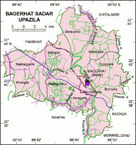
Bagerhat Sadar is located at 22°39′45″N 89°47′30″E/ 22.6625°N 89.7917°E / 22.6625; 89.7917 . It has 45527 units of house hold and total area 272.73 km².
Demographics
Bagerhat Sadar (Town) The municipality was established in 1958. It consists of 9 wards and 31 mahallas. It has an area of 7.53 sq km and population 51504; male 52.24%, female 47.76%. The literacy rate among the town people is 59.1%. The town has one dakbungalow and one circuit house.
Administrative
Bagerhat Sadar has 12 Unions/Wards, 187 Mauzas/Mahallas, and 167 villages
Archaeological Heritage
Shatgumbad mosque, Nine-dome mosque, Chillakhan and Sona Mosque, Anarkha Mosque, Dariakha Mosque, Katani Mosque, khan jahan’s tomb, Pacha Dighi, Ekhtiarkha Dighi, Burakha Dighi.
Historical Events
Khan Jahan Ali established pargana called Khalifabad covering Bagerhat, Khulna, Jessore, Satkhira and Barisal in 1429 AD. Shat Gumbad Mosque was the central administrative place of the kingdom. He built a Takshal (mint), several mosques and excavated several dighis (lakes). During the war of liberation Razakar Seraj Master (known as Zallat) slaughtered 18 members of a family. Battles between the Pak army and the freedom fighters were held at Panighat, Devir Bazar and Madhav Kathi. Marks of the War of Liberation Mass grave 1 (Bandhapara), memorial monument
Population
Total population 235848; Male 51.22%, Female 48.78%; Muslim 77.45%, Hindu 22.06%, Christian 0.42%, others 0.07%.
Religious institutions
Mosques 292, Temples 116, Church 1, Tomb 5.
Literacy and Educational Institutions
Average literacy 49.9%, Male 55.3%, Female 44.2%. Government college 2, non government college 1, Government High School 2, non-government High School 42, Government primary school 110, non-government primary school 43, technical institution 2, madrasa 53, homeopath college 1. Noted educational institution: Government P C College (1918).
Newspapers and Periodicals
Dainik Dakhin Kantha, Dainik Dut and Dainik Uttayal.
Cultural Organizations
Public library 4, museum 1, cinema hall 2, theatre party 2, rural club 25, drama stage 1, open stage 1, women’s organization 1, playground 1.
Main Occupations
Agriculture 29.64%, fishing 2.34%, agricultural labourer 14.04%, wage labourer 8.02%, commerce 15.95%, transport 5.61%, service 10.67%, others 13.73%.
Land Use
Cultivable land 20553 hectares, fallow land 200 hectares; single crop 56%, double crop 38%, treble crop 6%; land under irrigation 2.20%.
Land Control
Among the peasants 11% are landless, 23% marginal, 33% small, 24%, intermediary and 9%, rich farmers; arable land per capita 0.08 hectare.
Value of Land
Market value of first grade land is about Tk. 5000 per 0.01 hectare.
Main Crops
Paddy, wheat, jute, potato, banana and papaya, garlic, onion.
Extinct and Near to Extinct Crops
Mustard seed, tobacco.
Main Fruits
Safeda, mango, jackfruit, banana, papaya, ata, jamrul.
Livestock & Fisheries
Fisheries, dairies and poultries Hatchery 2, shrimp cultivation (Chingri gher) 1290, poultry 149, dairy 18.
Communication Facilities
Roads: pucca 72 km, semi pucca 38 km; waterways 13 km; Railways 12.75 km.
Traditional Transport
Palanquin (extinct), horse carriage and bullock cart (nearly extinct), boat.
Mill & Factory
Manufactories Spices grinding mill 28, flour mill 22, rice mill 25, ice factory 20, coconut oil mill 28.
Cottage Industries
Goldsmith 70, wood work 120, blacksmith 40, welding 60, honey cultivation project 1, bidi factory 1, bamboo work 40.
Hat Bazaar
Hats, bazars and fairs Hats and bazars are 31, the most noted of which are Jatrapur, Barakpur and Bbburhat; fairs 2 (Pir Khan Jahan Ali Mela and Rath Mela)
NGO Activities
CARE, Brac, Proshika, Asa, Shapla Phul, Dak Diya Jai, Apon, Codec, Dip.
Main Exports
Coconut, Betel-nut, Shrimp, Palm molasses.
Health Centers
Government hospital 1, Satellite clinic 2, Union health and family planning center 10, Child and maternity clinic 1, TB clinic 1, Private clinic 7, Nursing training center and school 2.