Geography
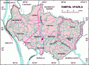
Rampal is located at 22°34′00″N 89°39′50″E / 22.5667°N 89.6639°E / 22.5667; 89.6639 . It has 33119 units of house hold and total area 335.46 km².

Demographics
As of the 1991 Bangladesh census, Rampal has a population of 167070. Males constitute are 50.83% of the population, and females 49.17%. This Upazila’s eighteen up population is 93518. Rampal has an average literacy rate of 45.5% (7+ years), and the national average of 32.4% literate.
Administrative
Administration Rampal thana was established in 1892 and was turned into an upazila in 1983. It consists of 11 union parishads, 131 mouzas, 149 village.
Historical Events
During the War of Liberation many local people were killed and wounded in an encounter between the freedom fighters and the Razakars at village Dakra on May 21, 1971. Mark of War of Liberation Mass grave and memorial at Dakra.
Religious Institutions
Mosque 204, temple 68 and church 2, most noted of which is Rampal Jami Mosque.
Population
Total Population 167070; male 50.83% and female 49.17%; Muslim 75.31%, Hindu 24.42%, others 0.27%.
Literacy and educational institutions
Average literacy 45.5%; male 51.5%, female 39.2%. Educational institutions: college 3, high school 27, government primary school 67, junior school 16, non-government primary school 46 and madrasa 88. Noted old institution is Gilatala Multilateral High School (1929).
Cultural Organizations
Public library 1, shilpakala academy 1, community hall 4 and rural club 26.
Main Occupations
Agriculture 33.52%, fishing 3.63%, sericulture 1.79%, agricultural labourer 20.13%, wage labourer 6.92%, commerce 13.97%, transport 1.34%, service 4.87%, others 13.83%.
Land Use
Arable land 20857.95 hectare and fallow land 4.04 hectares; single crop 43.26%, double crop 36.24% and treble crop land 20.50%.
Value of Land
Market value of first grade of land is Tk. 5000 per 0.01 hectare.
Main Crop
Paddy.
Extinct and Nearly Extinct Crops
Sugarcane and betel nut (nearly extinct).
Main Fruits
Mango, black berry, papaya, banana, palm.
Livestock and Fisheries
Fisheries, dairies and poultries Fishery 913 (shrimp cultivation), poultry 66 and dairy 4, artificial breeding centre 1.
Communication Facilities
Roads: pucca 30 km, semi pucca 19 km and mud road 378.
Traditional Transport
Palanquin (extinct) and taburia boat (nearly extinct).
Mill & Factory
Auto rice mill, ice factory and welding.
Cottage Industries
Weaving 23, wood work 206, blacksmith 30, goldsmith 20 and tailoring 178.
Hat Bazaar
Hats, bazars and fairs Hats and bazars are 28, most noted of which are Gilatala, Kayla and Porakhali Bazar.
Main Exports
Shrimp.
NGO’s Activities
Operationally important NGOs are asa, brac, caritas.
Health Centres
Health centres Upazila health complex 1, satellite clinic 1 and family planning centre 10.
 Bagerhat Info Largest Bagerhat Online Portal for Latest News, Blog, Informations & Many More