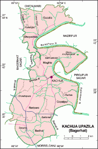
Geography
Kachua is located at 22°39′00″N 89°53′00″E / 22.6500°N 89.8833°E / 22.6500; 89.8833 . It has 18553 units of house hold and total area 131.62 km².
Demographics
As of the 1991 Bangladesh census, Kachua has a population of 93249. Males constitute are 50.36% of the population, and females 49.64%. This Upazila’s eighteen up population is 49921. Kachua has an average literacy rate of 42.5% (7+ years), and the national average of 32.4% literate.
Administrative
Kachua thana was turned into an upazila in 1983. It consists of 7 union parishads, 75 mouzas and 96 villages.
Archaeological Heritage
Shibpur Shivabari (1300 AD).
Historical Events
During the War of Liberation (1971) the Razakars killed 42 innocent people at Shakharikathi Hat of Badhal Union. Mark of the War of Liberation Mass grave 7, memorial 2.
Population
Total Population 93249; male 50.36%, female 49.64%; Muslim 76.39%, Hindu 23.58% and others 0.03%.
Religious Institution
Mosque 155, temple 37, sacred place 2, most noted of which are Kachua Jami Mosque and Shivabari Mandir.
Literacy Rate and Educational Institutions
Average literacy 42.5%; male 47.5%, female 37.3%. Educational institutions: college 2, high school 16, madrasa 8, government primary school 48, non-government primary school 42. Notable institutions: Goalmath Rashikpal High School (1916) and Baraikhali Government Primary School (1918).
Cultural Organizations
Public library 1, cinema hall 1, theatre group 1, rural club 20, women’s organisation 34.
Main Occupations
Agriculture 39.08%, fishing 2.28%, agricultural labourer 21.98%, wage labourer 5.96%, commerce 13.46%, transport 2.6%, service 5.91%, others 8.73%.
Land Use
Arable land 8991.09 hectares, fallow land 50.58 hectares; single crop 48.39%, double crop 48.32% and treble crop land 3.27%.
Land Control
Among the peasants 10% are landless, 2% small, 70% intermediary and 18% rich; per head arable land 0.09 hectare
Value of Land
Market value of land of first grade land is Tk 5000 per 0.01 hectare.
Main Crops
Paddy, sugarcane, pulse, vegetables.
Extinct and Nearly Extinct Crops
Mustard seed, til, sweet potato, groundnut, tobacco.
Main Fruits
Coconut, betel nut banana and sabeda.
Livestock and Fisheries
Fisheries, dairies and poultries Fishery 346, poultry 44, dairy 20.
Communication Facilities
Roads: pucca 57 km, semi pucca 21 km and mud road 257.88 km.
Traditional Transport
Bullock cart, palanquin. These means of transport either extinct or nearly extinct.
Mill & Factory
Rice mill 11 and saw mill 10.
Cottage Industries
Bamboo work 55, goldsmith 32, blacksmith 58, potteries 30 and wood work 120, tailoring 110.
Hat Bazaar
Hats, bazars and fairs Hats and bazars are 16; fairs 10, most noted of which are Kachua Hat, Goalmath Bazar, Baruni Mela and Shivabari Mela.
Main Exports
Coconut, betel nut, palm molasses.
NGO Activities
Onnesha, Help, Life Association, Prodeepan, brac, asa, grameen bank and CARE.
Health Centers
Upazila health complex 1, community clinic 5, family planning centre 7 and satellite clinic 2 .